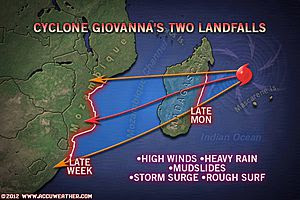
For Madagascar, there can be no escaping the imminent threat of a large Tropical Cyclone.
Tropical Cyclone Giovanna is currently north of the islands of Port Louis and Reunion, and is barreling southwest toward the eastern Madagascar coast.
Despite warm ocean waters and a lack of significant wind shear, Giovanna has undergone some minor weakening over the past 12 hours. However satellite pictures reveal that this may be related to an eye-wall replacement cycle, meaning the system may emerge today stronger than ever.
Favorable conditions will continue all the way to the Madagascar coast, in fact recent data would seem to suggest that conditions are improving for strengthening.
When Giovanna gets to the island between late Monday and early Tuesday, the system should bring substantial impact. Sustained winds over 115 mph with gusts over 130 mph are forecast for landfall. Rough surf, flooding rains and storm surge will all be serious concerns to those on the island as well.
Locations away from the coast are not exempt, as torrential rains will only lead to mudslides in the mountainous rainforests inland.
Madagascar may not be enough to completely weaken the system by the time it reaches the west coast of Madagascar, and will enter the Mozambique Channel. Computer models currently point to the system successfully crossing Madagascar and entering the Mozambique Channel. There it may re-intensify before impacting the Mozambique coast

No comments:
Post a Comment